the great subtropical lake in the
Yangtze river basin with large
seasonal water level fluctuations
 Poyang Lake, 2011:
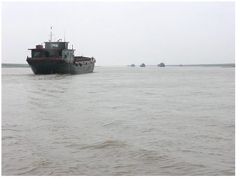
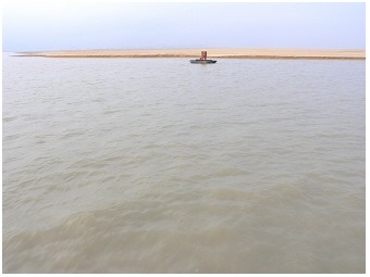
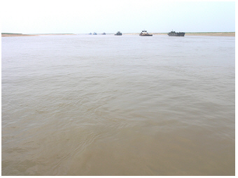
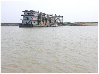
Even in the dry season the lake is an important waterway.
Large
vessels are still able to navigate the narrow channel in early spring
before the flood season.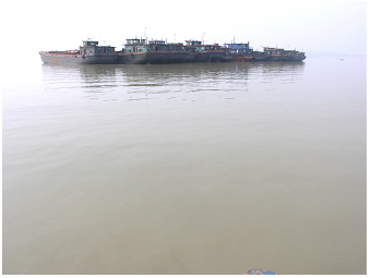 Poyang Lake, 2011:
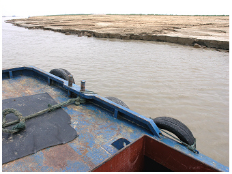
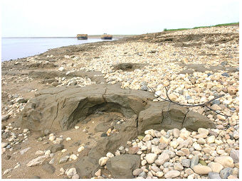
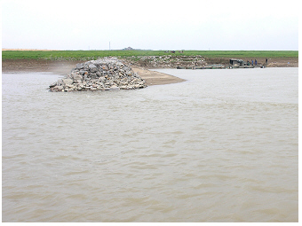
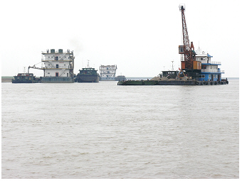
The area of the 'open lake' is rather narrow in the dry
season. Large vessels
build an 'off-shore island'.
 Poyang Lake, 2011:
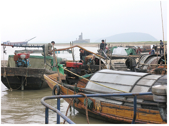
This small fishery port at city Xingzi is the northernmost site
described here for Poyang. In the background of the photo the unique
rocky island with temple buildings called the 'Fallen Star Pier' is
seen.
 Poyang Lake, 2011:
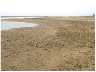
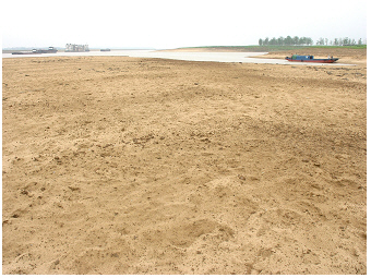
Large areas of the lake sand banks are above the water in
early spring, at the end of the dry
season
before the rain in May.
Lake Poyang (29°7’31.1''N,
116°16’39.7''E) is at seasonal periods of high
water level (Liu et al. 2016 R), i.e.
in summer and autumn, the greatest
freshwater lake in China. The shallow lake is located
4-10
m above sea level, in the Jiangxi Province. The lake is mainly
surrounded by large
floodplain
wetlands and is thus also the largest
lake-wetland area in
the country.
The water level of Poyang changes by seasonal flooding by
up to 14 m (personal communication, spring 2011).
According to the 16 month study from September 2011 to December 2012 by Liu et al (2016) R, the annual water level fluctuation was 11 m, with
a seasonally varying water level from 8 to 19 m.
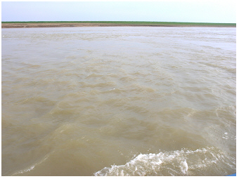
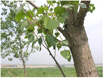
Poyang in winter looks mainly like a river delta,
flowing
around wide sand bank areas (dry
season); in summer, Poyang turns into
a large lake (wet season).
Poyang hence passes transient stages of a river and lake ecosystem
every year.
The description on this website refers to the northern part of
the lake only. It further relates to the navigable main channel trough
the lake – this was actually the only way possible to carry out field
sampling by boat during this visit in dry season. The northernmost
location described here is the fishery port at the city Xingzi. The small
port is close to the historical spot of a miniature of the rocky
island
with temple buildings, called the ‘Fallen Star
Pier’
(29°26’10.17''N,
116°1’42.59''E), which is located on the west
shore of the lake. The series of lake
photos shown in the gallery starts at this point and is going south.
After passing a rather narrow navigable stretch with wide dried-out
sandbanks on the east shore, a noticeable landscape point appears, a
hill with a
park of wind turbines (gallery photos 20 and 21). Here
Poyang
looks like a lake even in the dry season. Going further south on the
lake,
again the narrow navigable main and side channels were passed during
the
lake
sampling journey. The three wetlands that are described by their
vegetation
covered in the text, are also introduced from the north to south. The
photos of the third wetland, called on this website ‘matured wetland’
are taken from the most southern part of this sampling journey.
 Poyang Lake, sand
banks
above water, 2011:
Poyang Lake, sand
banks
above water, 2011:
In the dry season large areas of sand river banks are above the water.
The
yellow colour indicates the pure sand without a large lake
sediment
surface layer (no significant amount of 'organic mud' is covering the
surface).
 Poyang Lake, sand
banks
above water, 2011:
Poyang Lake, sand
banks
above water, 2011:
The same as the left photo, but an
area with more lake sediment
containing detritus ('organic mud').
 Poyang Lake, sand
banks
above water, 2011:
Poyang Lake, sand
banks
above water, 2011:
'Ploughed' sand - footmarks of livestock indicate grazing on the
wetland down to the water's edge.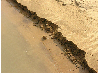 Poyang Lake, sand
banks
above water, 2011:
Poyang Lake, sand
banks
above water, 2011:
Crystal-clear water at the water's edge of pure sand banks - suspended
solids (silt, mud) deposit rapidly as turbulences are low in the
calm
shoreline zone.
The photos on this website were taken from two sampling journeys
in 2011, at the
end of April and in early May. They are hence showing the
lake during the dry season. Colleagues commented that after ‘heavy rain
for more than one week’ by the end of May in that year, Poyang had been
filled up and looking ‘like a real lake’ again.
The water regulation of the lake has been changed with the construction
of the
Three Gorges
Dam that was completed a few years ago (see
Yangtze S
on this
website).
 Poyang Lake, water's
edge in the
dry
season,
2011:
Poyang Lake, water's
edge in the
dry
season,
2011:
Round pebbles and pieces of grey clay are found on the sand
bank of the illustrated site of the 'matured wetland' (see description
of vegetation for the wetland below).
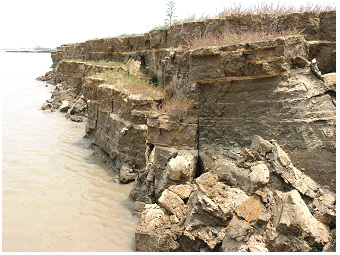 Poyang Lake, water's edge in dry
season,
2011:
Poyang Lake, water's edge in dry
season,
2011:
Horizontal layers of fine particle sizes are seen on the water's edge,
i.e. of sand and lake sediment material. The sharp soil edge is not
shaped by environment but human activities. It is due to dredging
(maintenance of the navigable channel) and further undermining by water
waves when vessels pass the navigable stretch. Sand dredging vessels
are seen left in the background.
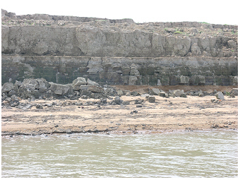 Poyang Lake, water's
edge in dry
season,
2011:
Poyang Lake, water's
edge in dry
season,
2011:
Eroded horizons as described for the photo above right, but of rather
grey clay color.
 Poyang Lake, water's edge in dry
season,
2011:
Poyang Lake, water's edge in dry
season,
2011:
Groynes are constructed perpendicular to the lake bank in some
sections of navigable narrow stretches.
poyang: the shallow turbid lake
serves as habitat
for many organisms from aquatic microbes to molluscs, snails, shrimp
and fish
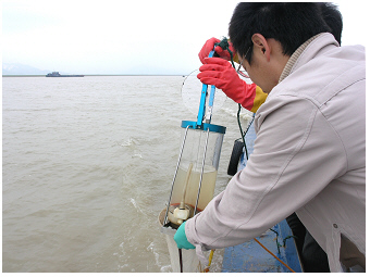 Poyang Lake, phytoplankton
net sampling,
2011:
Poyang Lake, phytoplankton
net sampling,
2011:
A 'Ruttner'-sampler is used to take the water sample from the lake
surface layer. The water in the glass tube of this sampler looks turbid
yellow-brownish. In addition to non-filtered samples for water
chemistry and phytoplankton estimation, five liters of lake water are
passed through the plankton net of 10 µm mesh size (see net below the
sampler). This sample is called the 'net sample' (see also text).
In this subtropical lake, gloves must be worn while sampling to avoid
skin contact with the water and hence an infection with parasitic
trematodes (schistosomiasis, bilharzia).
The water transparency is low (Liu et al 2016 R), mainly due to large concentrations of
inorganic suspended solids (silt) similar to the high turbidity of
water in the lake Taihu (Chen et al. 1993 R
and 1993 R; also this
website S)
and the Yangtze River (this website S). The low
water
transparency can be easily seen when a glass is filled
with the lake water as a
‘Ruttner’-sampler (see photo leftside). The mixing of water
column and flow
keeps the inorganic particles of silt and clay suspended. In the case
of
low water movement (see photo of crystal-clear water in the
introduction about shores with sand banks), the particles
deposit
and the lake turns from turbid water to clear water if no other
particles such as floating algae further reduce the water
transparency.
The results of conventional measurements of chemical, physical and
biological parameters according to the standard method for lakes will
not be sufficient to understand such a
turbid aquatic ecosystem. The
picture of the crystal-clear water at the calm water’s edge but the
muddy water
a few centimetres outside the channel, just illustrates the high
spatial resolution and also the dynamic in such a turbid lake (see
photo above and gallery photos 38-40). Lake
processes, which usually
occur primarily at the sediment-lake water interface or on the
shoreline on biofilms, are ‘translocated’ to the water column by
free-floating particles in
Poyang. These
suspended solids (silt and associated matter) provide a large surface
area, ‘a place to live’, and
serve as a micro-habitat for attached living micro-organisms, in the
main for bacteria, but also for algae. High-resolution measurements in
space and time of biota-environment interactions might enhance the
understanding about such a 'mobile' micro-habitat. The importance of
other micro-habitats as ‘marine snow’ (‘lake snow’) and
‘biofilms’ has
been discussed in other studies for particular aquatic ecosystems.
Furthermore, silt can physically adsorb chemical compounds for
a certain period.
The capacity of transient
adsorption of ions, as nutrients like
phosphate, will affect the turnover of essential nutrients
in such a
turbid lake. Finally, the suspended solids definitely reduce the
availability of light needed for photosynthesis. The underwater light
climate in Poyang might primarily
favor low light or shadow adapted
phytoplankton
species such as diatoms and
cyanobacteria (see also the blooming of diatoms in spring and autumn
and various taxa of cyanobacteria involved in blooms in spring
and
summer, which are described for shallow, well mixed turbid water bodies
of so called 'riverine lakes', on the website about Grosser
Mueggelsee S).
The low-light regime might be
mainly responsible
for the inhibited growth of algae, which results in only low biomass of
phytoplankton in Poyang whatever the actual potential for algal growth
by enhanced nutrient availability in Poyang is.
Besides the mentioned ecological aspects of high amounts of suspended
solids in the water, methodological problems analyzing the water in
such a turbid lake arise. Devices measuring fluorescence for a rough
estimation of ‘algal biomass’ in lake water, for example, are developed
for water bodies where turbidity is primarily determined by floating
photosynthetic micro-organisms, the phytoplankton
organisms. In the case of
brownish water bodies such as Poyang and Taihu, the measure suffers
from a
too high background from inorganic solids and the relative low
fluorescence signal
from phytoplankton. Phytoplankton samples are also
difficult to observe under the light microscope as the many inorganic
particles distract from the few algae occurring in the sample. Here, a
separate analysis of two size
fractions of phytoplankton can be
recommended. It is worth mentioning that small algae (less than 10 µm)
are commonly more frequent in a lake water sample than large algae
(greater than 10 µm). In water bodies without the dominance of
colony-forming cyanobacteria, the small cell size fraction of 0-10 µm
contributes more than 50% to the total chlorophyll concentration of
phytoplankton (Teubner
et al. 2001 R).
The small phytoplankton species can be enumerated among
the plentiful silt particles under the microscope when a small sample
volume is carefully observed at high magnification (microscopy on a
non-filtered
phytoplankton-water sample).
In addition, a sample might be taken using a net of 10µm mesh size to
eliminate silt particles (even more
appropriate would be a net of 5µm mesh size). In this net
sample, the
relatively rare but large phytoplankton species are enriched, making it
suitable for quantitative microscopical analysis. In addition to the
phytoplankton biovolume estimation by microscopical counting, the
chlorophyll-a
concentration of the non-filtered water sample might be
analysed. The results of both measures, of the 'tricky' phytoplankton
biovolume and of the 'simple' chlorophyll-a extraction (Greisberger
& Teubner
2007 R)
, might correspond to each other, i.e. might
validate each other.
The shallow muddy lake is not only the habitat for floating microbes
but also for many aquatic
animals.
The photos below illustrate some species of
molluscs as snails and mussels; and
fish mainly found on the 'sand bay wetland'
site. The photo of the lost catch from fishers shows small fishes and
various species of shrimp
that
are common in Poyang.
Fish and shrimp are sought not only by fishermen but are also the
preferred food for the
finless porpoise
(see more details about
this species described in the following two sections, the
'habitat of
finless porpoises' and the Poyang resource 'use by people').
 Poyang Lake, animals living
in the lake,
2011:
Poyang Lake, animals living
in the lake,
2011:
The remains of shells of mussels on this rock far from the recent shore
mark the much higher water level in the wet season compared to
the dry
season when this photo was taken. Inset: Detail of shells of the
mussels.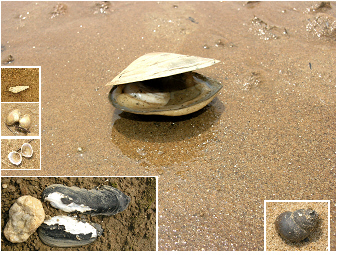 Poyang Lake, animals living in the lake,
2011:
Poyang Lake, animals living in the lake,
2011:
Various shells of mussels and snails are shown, which were found on
the water's edge of the wetland of the 'sand bay wetland' and the
matured wetland site' (see also the vegetation found at these wetland
sites described below). The snail shown in the inset right is
Bellamya aeruginosa, the snail in the small inset top left
Parafossarulus striatulus.
Further a common mussel species
in Poyang shown in the two small insets left below is
Corbicula flumine.
 Poyang Lake, animals living
in the lake,
2011:
Poyang Lake, animals living
in the lake,
2011:
The shell of the large mussel species (middle of the photo) can be more
than 25 cm long. To compare the size, small shells of
Corbicula flumine
are seen top left on the photo.
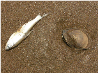 Poyang Lake, animals living in the lake,
2011:
Poyang Lake, animals living in the lake,
2011:
Stranded dead animals are found on the shore.
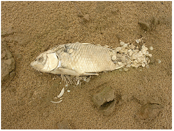 Poyang Lake, molluscs and
fish, 2011:
Poyang Lake, molluscs and
fish, 2011:
Remains of a fish dried in the air.
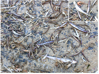 Poyang Lake, animals living in the lake,
2011:
Poyang Lake, animals living in the lake,
2011:
Lost catch of small fish and various shrimp species found at the small
fishery port of the city Xingzi.
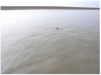
poyang lake:
the habitat of the finless
porpoise (Neophocaena
phocaenoides)
The finless porpoise, jiangzhu, also called the ‘river pig’,
is
systematically close to whales and dolphins. During a field sampling
trip by
boat early May 2011, these
animals could be identified by their
characteristic leaps from the water. Two series of
snapshots shown below illustrate such leaps. The leaps were sometimes
seen nearby in
front of the boat, but the porpoises were too close and fast
to
follow this scene with a simple digital camera. The leaps documented in
the snapshot photos could be taken only by a ‘leap-panorama view’.
These low-resolution
snapshots don’t really capture the excitement of the moment when seeing
the porpoises leaping,
but these photos are sufficient to document that these animal
species live in this lake.
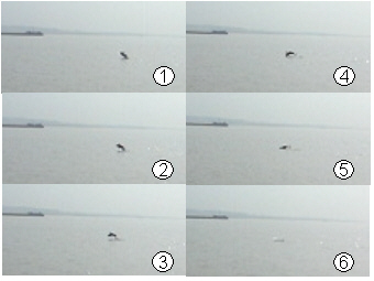 Watching porpoises on
the Poyang
Lake,
2011:
Watching porpoises on
the Poyang
Lake,
2011:
A leap of a finless porpoise (Neophocaena
phocaenoides) is shown by a series of snapshots. In the
background a large vessel in front of the landmark of the 'hill with
the park of wind turbines'
can be seen.
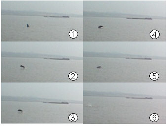 Watching
porpoises on the Poyang
Lake,
2011:
Watching
porpoises on the Poyang
Lake,
2011:
The same as the left photo but another leap of probably the
same individual.
 Watching porpoises on the Poyang
Lake,
2011:
Watching porpoises on the Poyang
Lake,
2011:
The water in-between the fishermen just handling their nets &
cages and the old
dredging vessel, a finless porpoise was seen – may be attracted by the
fisher’s business, looking around for catching a lost fish??? As
mentioned
in the text, the simple digital camera was too slow to catch this
scene with the porpoise - the animal is NOT seen in this photo.
The sampling boat was not going along the
busy navigable waterway
through the lake but rather the shallower lake areas. The sampling tour
began in the morning and returned in the early afternoon, lasting about
two hours in one direction, going from the Poyang
field research laboratory station at Xingzi (Poyang Lake Laboratory for
Wetland
Ecosystem Research station of the Chinese Academy of Sciences, PLWER of
CAS) to the south. During the
two-hour one way
trip about these animals
could be counted leaping about 40 times; and on the boat
sampling return journey way about
30 times.
Sometimes an individual animal was seen by a series of leaps; at other
moments the leaps indicated that these animals have formed a small
group near the water surface. The finless
porpoises were most frequently seen
in the more open lake area, where the ‘river channel’
broadens up near
to the ‘real lake’ at the ‘hill with the park of wind turbines’
(details in the introduction above), about 30 minutes away
from the
field research laboratory station. Furthermore some
leaps were seen in
the narrow ‘river channel’ in the south, onward leaving
the main
stretch, on a side stretch without sand dredging vessels and where less
frequent cargo vessels were passing (two photos below). One finless
porpoise was even seen
nearby in the fishery harbor, the reach at the station of PLWER (see
title of the right
text photo).
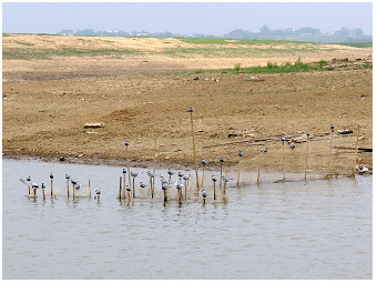
 Poyang Lake, habitat
of finless porpoises,
2011:
Poyang Lake, habitat
of finless porpoises,
2011:
Shallow shore areas of curling water, looking like a small eddy
surrounded by rapids, were the common places visited daytime by the
finless porpoises. Many leaps of these animals were counted
at such near shore habitats in late April/early May.
 Poyang Lake, habitat
of finless
porpoises,
2011:
Poyang Lake, habitat
of finless
porpoises,
2011:
On this concrete shallow shore area of rippling water, actually in
front of this herd of water buffaloes bathing on the shore, leaps of a
number of finless porpoise were seen.
 Poyang Lake, habitat
of finless
porpoises,
2011:
Poyang Lake, habitat
of finless
porpoises,
2011:
This buoy made by a plastic bottle marks the position of underwater
fish nets or fish traps. The shallow water is an attractive fishing
ground for
fishermen needing to earn their living. It is, however, also the
preferred ground visited by finless porpoises getting food. Gill nets
can become a dangerous trap for these rare animals.
 Poyang Lake, habitat
of finless
porpoises,
2011:
Poyang Lake, habitat
of finless
porpoises,
2011:
Leaps of finless porpoises were even seen near large vessels in narrow
navigable stretches - but not in the close neighborhood of noisy sand
dredging vessels often operating in clusters on the lake.
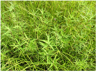
poyang wetland: the vegetation
cover differs among the marshland sites
Impressive large wetlands surround the water zone of
the
Poyang lake system. The vegetation covering the seasonal
wetlands is
probably best seen at the end of the dry period. Three wetland sites
are illustrated by photos and have been visited during two vegetation
surveys, at the end of April and early May in 2011. The sites briefly
described here are called: the wetland at the 'Fallen Star Pier',
wetland at the 'sand bay', and the 'matured wetland'. In addition to
the photos in this paragraph, the three sites are illustrated by the
gallery photos 8-13, 36-51 and 62-69, respectively.
The seasonal
wetland at the small rocky temple island (‘Fallen Star Pier’)
at the
city Xingzi, is a
large bay of ‘grass
land’ during the dry season. As described in the paragraphs
below about the
resource use of Poyang, this wetland was used as pasture. During the
vegetation survey, a herd of less than 80 cattle was seen grazing on
this large bay area.
Browsing damage by cattle was only found in some
marginal areas and mainly on grass of Poaceae (e.g. Phalaris
arundinacea) and a few plants of sedge-grass (Cyperaceae;
see also sustainable use of grass-land pastures in the catchment of
alpine lakes in Austria described on the website about lake
Attersee S).
The most impressive species of the native vegetation on this wetland
was
Beckmannia syzigachne.
This gramineae plant (Poaceae) was forming larger dense monospecific
stands in the more central part and the still moist areas of this
marshland.
The wetland inhabited further some temporary small water basins and
streambeds. The bottom of these shallow-water basins was densely
covered by the submerged
macrophyte Potamogeton crispus
(not shown here by a photo). The recently dried-out marshes of these
‘wet-spots’ were only
sparsely covered by terrestrial vegetation. The yellow flowering
composite plant, Lapsana
apogonoides, was here growing in association with some
short sedge grass (Carex
spp.).
At the margin of this wetland, or on the elevated rocky ground of the
island of the ‘Fallen Star Pier’ some plants commonly growing on rather
dry and ruderal fringe habitats, as e.g. the pink flowering laminate
plant Leonurus cardiaca
(Lamiaceae), were found.
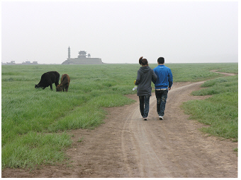 Poyang Lake, 2011:
The seasonal wetland that is surrounding the small rocky island of the
'Fallen Star Pier' Temple is popular for a walk in the dry season. This
meadow is also used as grazing ground. The east side of the wetland is
bordered by the lake. The Poyang indicated by large shipping vessels is
seen on left side of the
photo.
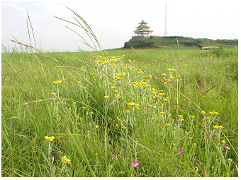
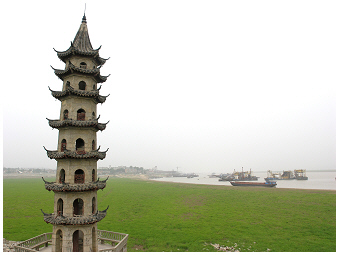 Poyang Lake, 2011:
View from the Temple of the ‘Fallen Star Pier’ in the dry-season
wetland
and the lake. The historic Pagoda, which is part of the temple complex
on the island, is built of stone. The small fishing port is seen in the
center of the photo in the background. The city Xingzi located on the
ridge, can be seen further left. The modern city has contemporary and
traditional housing areas. A narrow alley with old wooden residential
houses and buildings that are over 200 years old, is not far from the
fishing port.
 Poyang Lake, wetland at
'Fallen Star Pier',
2011:
Poyang Lake, wetland at
'Fallen Star Pier',
2011:
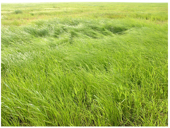
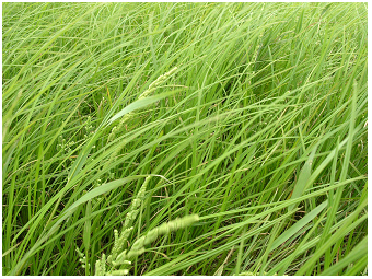
Wetland in early May, before the flood season. This tall
hygrophilous 'grass' vegetation is built by dense stands of Poaceae
(mainly Beckmannia syzigachne,
rarely Phalaris arundinacea)
and some few plants of Cyperaceae (diverse Carex
species).
 Poyang Lake, wetland at
'Fallen Star Pier',
2011:
Poyang Lake, wetland at
'Fallen Star Pier',
2011:
Dense stands of the sludge grass Beckmannia
syzigachne.
 Poyang Lake, wetland at
'Fallen Star Pier',
2011:
Poyang Lake, wetland at
'Fallen Star Pier',
2011:
The yellow flowering composite plant Lapsana
apogonoides
growths together with short reed of Carex
and Poacaea.
 Poyang Lake, wetland at
'Fallen Star Pier',
2011:
Poyang Lake, wetland at
'Fallen Star Pier',
2011:
A few plants of Leonurus cardiaca
growing close to the rock of the island indicate the rather dry than
moist habitat conditions in this narrow place surrounded by the wetland
meadow.
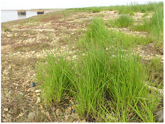
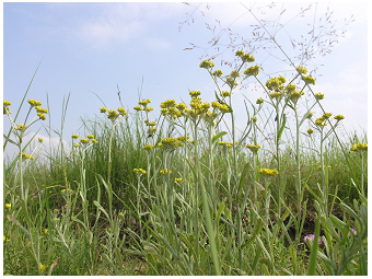
The second site described here is further south from the
noticeable
landscape point, the hill with the park of wind turbines (see above in
the introduction). This 'wetland
at the sand bay' was created by sand
dredging on the shore. On the water's edge, pure sand due to erosion
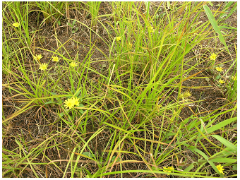
occurred. On the water-saturated marsh of the bay, species like
Alopecurus
aequalis, Ranunculus sceleratus
(see
photo below), Polygonum
hydropiper
(see gallery photo 44) and Echinochloa
crus-galli,
were found. Further land-side dense stands of various Carex
species and yellow
flowering composite Gnaphalium
affine dominated the wetland. With less
moisture, stands of
larger forbs as of Artemisia
selengensis, and
the grass Phalaris
arundinacea
covered the wetland. A few plants of Cirsium
arvense and Apiaceae occured sporadically among
the higher forbs. The wetland seemed to be commonly used as a pasture.
Browsing damage by cattle was mainly found on the short grass (Poaceae,
see plant right side of the gallery photo 46). Planted trees finally
delineate this wetland, which is the land-side further continued by a
meadow.
Some plants found on this wetland are known to be edible
plants. Young apical sprouts of Artemisia
selengensis are well-liked for vegetable dishes. Gnaphalium
affine is popular for tea but also edible, as students
told. Further it was said that the spikes collected from Alopecurus
aequalis and
similar species of this genus on marshes provides a valuable 'chicken
food'. These few examples are mentioned to convey that the
wetland is a
popular area visited by local people.
 Poyang Lake, wetland at
sand bay, 2011:
Poyang Lake, wetland at
sand bay, 2011:
Sand dredging formed this bay of pure sand ground, containing no
lake detritus (popularly called 'mud') on the water's edge.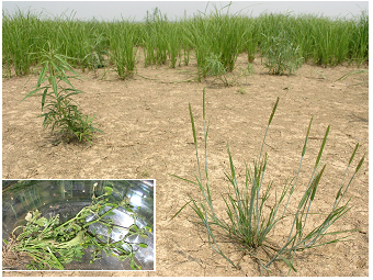 Poyang Lake, wetland at sand bay, 2011:
Short lived small forbs as Alopecurus
aequalis
(Poaceae) seen in the front right of the photo, built up the sparse
pioneer vegetation cover of the marshland.
Inset: The yellow flowering Ranunculus
sceleratus (Ranunculaceae) was collected from this mash
habitat during the vegetation survey.
 Poyang Lake, wetland at
sand bay, 2011:
Poyang Lake, wetland at
sand bay, 2011:
The perennial reed on 'middle-aged' wetland is built by various species
of Cyperaceae (e.g. Carex spp.,
see hair-like leaves) and Poacaea (e.g.
Phalaris arundinacea seen here by broad leaf
blades).
A single terminal spike is typically found for the
single-spike species
group of Carex spp.-species
and can be easily overlooked.
 Poyang Lake, wetland at
sand bay, 2011:
Poyang Lake, wetland at
sand bay, 2011:
The less water saturated wetland on the lakeshore is
characterized by taller forbs: the yellow
flowering Gnaphalium affine
and Artemisia
selengensis (see non-flowering stems middle and left side)
are both composite plants and are popular as edible plants.
They grow here in association with dense stands of 'grass
plants' as of Carex
spec. (hair-like leaves, Cyperaceae) and Phalaris
arundinacea (broad grass leaves on the right, Poacaeae).
 Poyang Lake, wetland at
sand bay, 2011:
Poyang Lake, wetland at
sand bay, 2011:
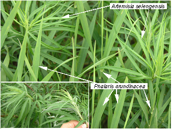
Dense stands of tall forbs mainly by Artemisia
selengensis and Phalaris
arundinacea that succeded on the further dried habitat of
the wetland. Inset: Artemisia
selengensis, young shoots of this plant are edible. Here,
however, the whole plants were harvested for analysis in the
lab.
 Poyang Lake, wetland at
sand bay, 2011:
Poyang Lake, wetland at
sand bay, 2011:
Planted trees close to the lake shore will foster the dry-out of the
marshland and hence promote the shrinking and the loss of valuable
wetland habitats in the land-water ecotone of Poyang.
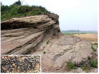
The third wetland site is named here the
'matured wetland'. Different
from the sandy shoreline of the 'wetland at the sand bay',
pieces of clay
were common on the shore of this wetland site (see
shoreline photo
above about 'the water's edge in dry season'). As described before,
Poacea with a short growth cycle (as e.g.
Alopecurus aequalis)mainly settled on the moistore
marshland. Going further land-side the wetland cover changed to stands
of short
Carex,
continued by a meadow of
Carex associated either with Astragalus
sinicus
and Gnaphalium
affine or with Artemisia selengensis
(see text photos below about the 'matured wetland site' with dense
vegetation stands). On the more distant elevated bank, a meadow
vegetation was mainly
built from rather taller Poaceae as e.g. by
Festuca spp..
 Poyang Lake, matured
wetland site,
2011:
Poyang Lake, matured
wetland site,
2011:
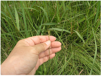
Zonation on the shoreline from the water's edge to marsh vegetation.
Tufts of a sedge species (Carex spec.)
are seen in the front right of the photo.
 Poyang Lake, matured
wetland site,
2011:
Poyang Lake, matured
wetland site,
2011:
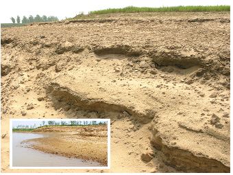
Soil erosion at the water's edge - it is the most vulnerable
zone for vegetation on the lake shore: Small ephemeral flowering plants
are able to germinate, grow and form seeds during their very
short life, lasting days to weeks in the dry season in early spring
before flooding the marshes.
 Poyang Lake, matured
wetland site,
2011:
Poyang Lake, matured
wetland site,
2011:
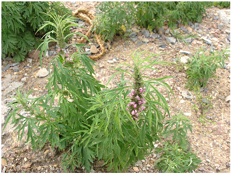
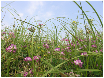
The pink flowering legume plant Astragalus
sinicus (Fabaceae) is commonly found together with yellow
composite Gnaphalium affine
(Asteraceae) and sedge Carex
spec.
 Poyang Lake, matured
wetland site,
2011:
Poyang Lake, matured
wetland site,
2011:
Dense stands of perennial forbs as of Artemisia
selengensis and Carex spec.
 Poyang Lake, matured
wetland site,
2011:
Poyang Lake, matured
wetland site,
2011:
The habitus of Gnaphalium affine
looks here very similiar to that of the species Helichrysum
arenarium, commonly found on sandy ground in Northern
Europe. Further, a panicle of a tall grass of Poacae, 'Deschampsia' -like
is seen.
 Poyang Lake, matured
wetland site,
2011:
Poyang Lake, matured
wetland site,
2011:
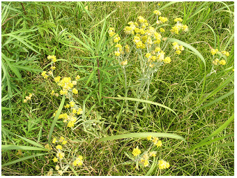
Meadow with Gnaphalium affine
and Astragalus sinicus
among grasses as of various species of Cyperaceae (Carex spp.) and Poaceae (Festuca spec.).
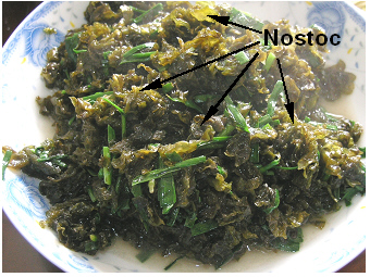
Besides higher plants also algae and cyanobacteria may occur on soil.
The
sandy loam in the Poyang marchland is
the habitat of the soil cyanobacterium Nostoc
commune. This colony
forming cyanobacterium is easy to find on soil surface during
the wet season. The colonies survive even the dry season
and look then like algal paper. It is an edible
cyanobacterium and usually harvested after rain, when the
colonies are
swollen (see morpho-cytology and chemical
composition of Nostoc commune
used as human food in Briones-Nagata et al. 2007 R;
it is popularly also described as 'edible alga' or 'algal food' even it
is not alga but a cyanobacterium;
see also Nostoc commune in
the gallery photos for the pond
Biotop Auersthal S). The gelatinous
colonies need to be washed carefully before
being boiled or
fried (to be cleaned from sand and soil). Seasoned with spring onion or
garlic the Nostoc commune
dish is
served with rice in China. Some other cyanobacteria such as other
colonial Nostoc
species found in freshwater habitats and Spirolina
grown in cultures can also serve as human food and supplementary food,
respectively (see more details about cyanobacteria on the page
Lab View S).
Other taxa of
freshwater cyanobacteria, however, such as Microcystis
(see
Dianchi S,
Grosser Mueggelsee S,
Taihu S),
Anabaena,
Aphanizomenon (see
Bergknappweiher S), Cylindrospermopsis
raciborskii
(see
Old Danube S)
and Planktothrix
rubescens (see
Ammersee S
and
Mondsee S)
are not food as they are known to be able to produce
cyanobacterial toxins.
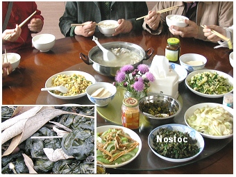 Nostoc
commune; Breakfast at Poyang research station,
2011:
Nostoc
commune; Breakfast at Poyang research station,
2011:
Food - prepared dish with Nostoc
commune.
Inset: The cyanobacterium was locally harvested from soil near
the
Poyang shoreline.
 Nostoc
commune; Breakfast at Poyang research station
2011:
Nostoc
commune; Breakfast at Poyang research station
2011:
Food - dish with boiled Nostoc
commune
seasoned with leaves of spring onion.
poyang - the large lake-wetland system:
the use by the people
The lake use of Poyang is manifold and refers here to fishery, agriculture,
raw building material extraction
and navigation
shown by photos on this website.
Gillnets and fish
traps shown below and also
shrimp fishing enabled to
harvesting of even the small size animals of various small fish and
diverse
shrimp species. A photo of such a small fish catch is shown in the
gallery by photo 7 and the text above in the section 'animals in the
lake'.
 Poyang Lake, local fishery,
2011:
Poyang Lake, local fishery,
2011:
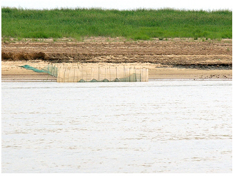
Gillnets are put out in the shallow water.
 Poyang Lake, local fishery,
2011:
Poyang Lake, local fishery,
2011:
Fisher boat with net of small mesh size to catch small animals of fish
and a various shrimp species common in this sub-tropical lake.
 Poyang Lake, local fishery,
2011:
Poyang Lake, local fishery,
2011:
Waterfowl have a rest on bamboo constructions of gillnets &
fish traps.
 Poyang Lake, local fishery,
2011:
Poyang Lake, local fishery,
2011:
Gillnets and fish traps on the shallow lake bank are covering the range
of short-time water fluctuation.
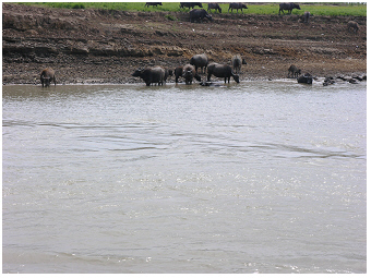
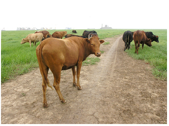
The lake-wetland area is commonly used for
livestock
grazing. Even the quality of food differs with habitat
conditions for
vegetation growth on the wetland; many floodplain areas in the north of
the lake are used as a pasture. Usually the number of
cattle in a herd
is small. For example, about 80 animals only were grazed on
the
larger floodplain bay-area at the 'Fallen Star Pier', which indicates a
sustainable use of the wetland.
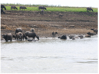
Seasonal herding of about 100
water
buffaloes could be further seen on wetland pasture.
The herd was moving along the shoreline of the navigable channel.
 Poyang Lake, 2011:
Livestock grazing on the wetland, here shown for cattle on the seasonal
marshes at the rocky island of the ‘Fallen Star Pier’.
 Poyang Lake, 2011:
Livestock grazing on the lakeshore: A herd of water buffaloes bathing
in
the shallow lake zone.
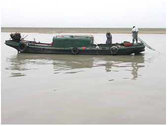
The scenery of traffic in dry season, on the ‘Poyang-river', can be
described on narrow stretches by a few
small fishermen boats, many
operating sand-dredging vessels and plenty
of large cargo vessels
passing the ship channel.
Sand dredging is
now a common business on the lake. Dredging seems to
have been done to maintain navigable channels, at least in periods of
very low water level in the dry season. Furthermore, tons of sand are
needed to satisfy the great demand in the current construction
industry. On this side, lake Poyang is used as an important source for
extracting sand and clay from the underwater lake banks. On the other
side, sand dredging in Poyang has a definite impact on the
ecosystem.
'Newborn' bays are created, and shape niches for
biota connected to the lake along the channel. A channel with
integrated small bays will increase the diversity
of the habitat structure
in the lake, might stimulate the growth of biota that
benefits from low
flow velocity and less washout. This biota might be different from
biota growing well in the main channel. The sand bays will be
successively inhabited as pioneer habitats. The settling of biota from
bacteria to algae and small animals, however, proceeds not 'over night'
but takes longer, proceeds successively over a time of weeks or even
months. The settling of these pioneer
habitats cannot proceed faster
than the life span or the generation time of these individual organism
groups is. In turn, sand dredging destroys the 'matured' habitats that
are important as spawning and nursery feeding grounds. The balance
between the creation of new structures being processed by the biotic
life-activity to become a ‘new habitat’, and the harsh deterioration of
'matured' habitats (spots
of life) will answer the question: What is the impact of sand
dredging on aquatic biota in Poyang?
Another impact of sand dredging on the ecosystem comes by
noise pollution.
An old 'small' sand-dredging vessel is shown in the
gallery (photos 59&60). The new dredging vessels are much
bigger and have much larger sand dredging capacities. These vessels are
often operating in clusters on the lake. In addition, the high capacity
of extracting sand requires a likewise high capacity for the
transportation
of sand. Many large vessels ready to be loaded are therefore
accompanying the bulk of sand dredging vessels. The operating of
dredging vessels, the busy loading of vessels and navigation, and
in-between further some small boats related to this business - have
changed the silent place of the lake to a busy noisy motor-waterway.
The noise pollution impacts above but also under water nearby habitats.
The many vessels are narrowing the channel, in particular, in the dry
season and are shrinking in this way the space to live for fish and
finless porpoises. Leaps of finless
porpoises were seen in less busy
narrow channels, as e.g. northward 100 m away from the small fishery
port in Xingzi and in shallow main and side channels south from the
hill with the 'park with wind turbines' (location described in
introduction part). These animals, however, avoided busy areas of the
sand dredging machinery.
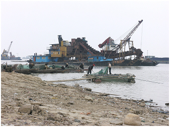
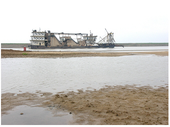 Poyang Lake, sand dredging,
2011:
Poyang Lake, sand dredging,
2011:
Large dredging vessels are navigating through the narrow water
channel in dry season.
 Poyang Lake, sand dredging,
2011:
Poyang Lake, sand dredging,
2011:
Dredging of sand and clay is important to keep up with the high growth
of construction industry. This lake use has, however, also an impact
on shore habitat of aquatic biota.
 Poyang Lake, sand dredging,
2011:
Poyang Lake, sand dredging,
2011:
Loading of vessels by sand from dredging vessels - the many vessels are
narrowing further the already slender channel in dry season.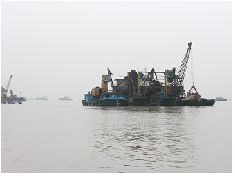 Poyang Lake, sand dredging, 2011:
Sand dredging in the lake to maintain the
navigation channel.
Finally, even if this aspect is already mentioned before, it is worth
highlighting again that lake Poyang
serves as an important
waterway. The north of the lake connects with the Yangtze
River. The many
material and goods seen on large cargo vessels ranged
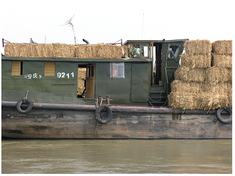
from oil, sand and clay to straw as illustrated by a few photos below.
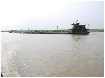
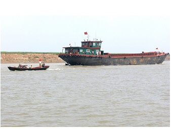 Poyang Lake as important
waterway, 2011:
Poyang Lake as important
waterway, 2011:
Small boats and very many large vessels are typically met on the
journey through the northern part of the lake that connects to the
Yangtze River.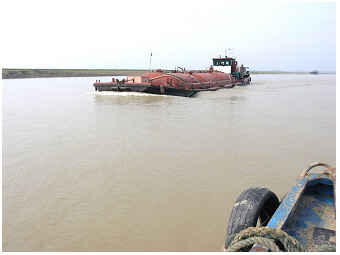 Poyang Lake as important waterway, 2011:
Shipment of goods.
 Poyang Lake as important
waterway, 2011:
Poyang Lake as important
waterway, 2011:
Shipment of straw.
 Poyang Lake as important
waterway, 2011:
Poyang Lake as important
waterway, 2011:
Shipment of fuel.
 >
>