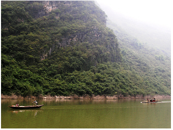
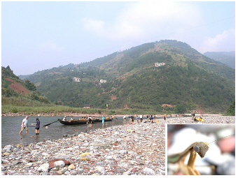
geographical location of the
stream
 Shen Nong stream, 2004:
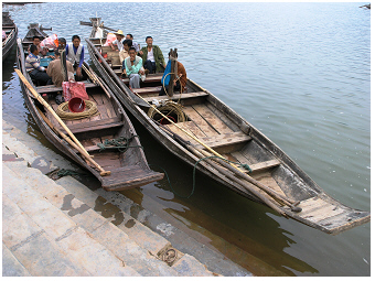
A common scene seen on the stream - local people are going by
traditional flat-bottomed wooden boats, that are called in Chinese
wooden-planked 'sam pans' (locally also called 'peapod
boat'). One can barely hear the sound of evenly-quiet rippling of the
rhythmic movement of rowing and steering.
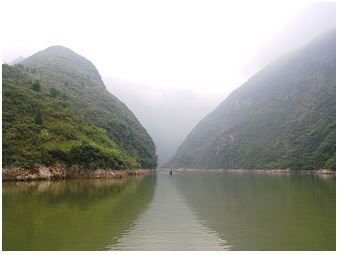 Shen Nong stream, 2004:
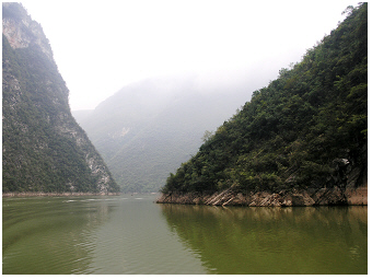
A common view of the stream not too far away
from it's mouth into
the Yangtze River - the stream meanders between rounded
valleys - the water looks
yellow-green
coloured. The water colour is not simply due to a reflection of the
forested slopes but rather a clear signature for the development
of floating, i.e. planktonic 'algae' in the downstream stretch.
The Shennong stream (Shen Nong Xi) is a tributary of the
Yangtze River. The mouth of the stream is close to the city Badong (31°02’
N 110°20’ E)
at 381 m above sea
level, located
in the Enshi Tujia and
Miao Autonomous Prefecture, the Hubei Province. The Shennong stream is
about 60 km long but navigable only for about a third of its
length at the time of the visit reported here, in 2004.
The scenic landscape, the history and tradition of people living at the
Shennong stream seemed to attract many tourists from China and abroad
(see gallery photo 9).
Visitors of the Shennong stream needed to change
the vessel, as large cruise vessels commonly used on Yangtze River
could not pass the narrower streambed of Shennong. Smaller cruise ships
were used for tourist traveling going about 20 km upstream the
Shen
Nong Xi. On a small harbour, at the end of the navigable
section,
visitors had to change again, from the ship to the boat. The local
people offered to go further
upstream by traditional
wooden boats (‘sam-pans’), to enter the shallow and narrow
mountain
stream channel (see gallery photos
12-13).
On the website here, the Shennong stream will be briefly
described for
the navigable 20 km (10 to 20km?) section close to
the mouth
into the Yangtze
River,
and for a further short stretch of the upstream ‘headwater mountain’
section.
the changing nature along the downward
flow of the stream:
the different faces of shennong xi.
The words of the idiom ‘panta
rhei’ refer to the flow of a river (in German
‘Alles fliesst/Alles ist im Fluss’) with the meaning that ‘everything
changes' or 'everything is in progress’. Indeed, ecosystem changes can
be identified
along the downward
flow of a river channel: from the mountain highland
to the mouth, where the stream joins into a larger stream
or river or
into a lake or ocean. As the landscape changes adjacent to the stream,
also the character of the streambed, the oxygen concentration,
temperature, flow velocity, turbidity and nutrient level alter.
Further, in accordance to this changing environment, the habitat
conditions and hence adjusted biotic communities alter successively. In
contrast to floating microorganisms, which are mainly passively
drifting with the downward flow, larger animals can move and therefore,
stay in a certain stretch where they prefer to live. Key
species of fish communities are thus commonly used to describe
particular zones of habitat conditions of a stream (zonation of
a
stream). Ecologists are describing the complexity of
biotic life in a river system and the connected floodplain by a
numerous concepts, which are not explained at all here. As the main
focus of the lakeriver-website is on algae in water basins, the
zonation of the Shennong stream will only be discussed with regard to
the water colour and the development of phytoplankton, i.e. in the
water floating or drifting photosynthetic micoorganisms.
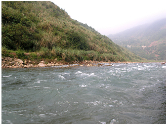 Mountain stream Shen
Nong, 2004:
Mountain stream Shen
Nong, 2004:
The water at mountain highland stretch looks
crystal clear.
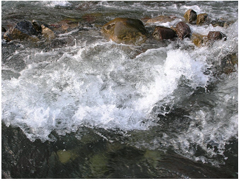 Mountain stream Shen Nong, 2004:
Splashing water along rapids passing the shallow stony streambed.
 Mountain stream Shen
Nong, 2004:
Mountain stream Shen
Nong, 2004:
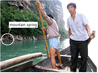
Going further upstream, steep rocky slopes shape the stream
bed
and mountain springs become frequently seen. The turquois-blue
colour
is just due to optical properties of the water, not due to floating
biota as algae in eutrophied, i.e. nutrient-rich, water bodies (see
also
deep-turquois coloured water of the alpine lake Traunsee S
on
this lakeriver-website).
 Mountain stream Shen Nong, 2004:
Detailed view onto the rocky slope bordering the stream channel.
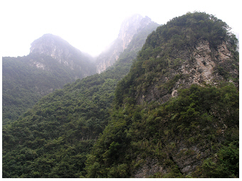
The four photos above are from the highland mountain
stretch
of the Shennong stream. The water tumbled over rocks and stones of a
shallow river bed and looked crystal clear. Mountain
springs could be
commonly seen on the rocky shore. At steeper holes, the deep
water
looked turquoise-blue. This colour was just due to optical
properties of
the water, not due to ‘blue-green algae’, the cyanobacteria. Another
water basin with deep-turquoise coloured water described on the
lakeriver-website
is the
alpine lake Traunsee S in the
Austrian Alps. In that oligotrophic, i.e.
nutrient-poor lake, the
rather blue-milky water colour is also not due to phytoplankton, but
due
to
suspended solids from the mountains.
Primary producers, such as planktonic
algae and cyanobacteria, cannot grow well in
the rapidly flowing headwater
for many reasons. Due to the strong current running, the growth of
cells of primary producers is inhibited by mechanical stress.
Furthermore,
the nutrients needed for phytoplankton growth are insufficiently
available in the headwater. The bordering landscapes are rocks where no
or only a thin layer of soil is on the surface. Thus, after rainfall,
the water does NOT receive larger amounts of nutrients simply by soil
erosion. Moreover, the steep rocky slopes at the headwater seemed to be
unsuitable, not a favourite place for housing and farming at the
Shennong stream. Accordingly, the anthropogenic impact of a nutrient
increase
played certainly no role on this stretch. The stony
stream bed and biota
found there are illustrated in the photos below.
 Mountain stream Shen
Nong, 1997:
Mountain stream Shen
Nong, 1997:
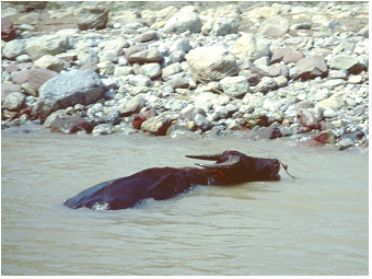
This is the only photo selected from a series taken by the author in
the late nineties from this stream. Before constructing the three
Georges Dam to raise the water level, the scene seen on the photo was
commonly found: Farmers allowed their water buffalos to bathe on the
shallow stream shore.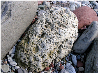 Mountain stream Shen Nong,
2004:
Mountain stream Shen Nong,
2004:
Various stones of different sizes were found on the shallow banks of
this stream. This environment was well suited as habitat for animals of
the so-called macro-zoobenthos and other organisms adjusted to such
stream conditions.
 Mountain stream Shen
Nong,
2004:
Mountain stream Shen
Nong,
2004:
Student excursion of the University of Vienna, organised by Chinese
colleagues. Sampling at the shallow streambed and banks ashore. Inset:
Detailed view of the head of the insect Miomantis. This
insect was found ashore.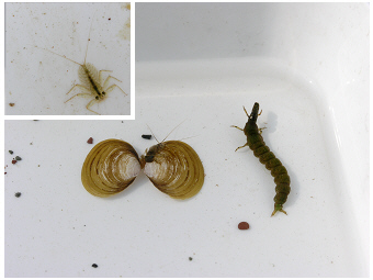 Mountain stream Shen Nong,
2004:
Mountain stream Shen Nong,
2004:
The animals found at the shallow streambed shown here are larvae of
insects and bivalve molluscs (Corbicula
flumine). All animals were collected alive during the
student excursion and were released back to nature after taxonomic
determination.
 Mountain stream Shen
Nong, 2004:
Mountain stream Shen
Nong, 2004:
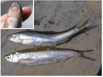
Fishes at this shallow stretch.
 Stream Shen Nong,
2004:
Stream Shen Nong,
2004:
Stony banks were common at the upstream shallow stretches of this
mountain stream. The Three Gorges Dam construction being built in that
period, however, will cause the habitat loss of these shallow
stretches.
Going further downward with the flow, the current is reduced and the
water meanders across valleys of less steep slope. In the case of the
Shennong stream, the stream became wider and deeper at a larger town or
city, the place where the habour for cruise ships was as the navigable
stretch ended here at that time of the visit in 2004. Both, the lower
current by meandering (longer retention time of water in a stretch) and
the increase of nutrients (loaded from the bordering landscape) support
in general the growth of
phytoplankton in a stream. While a stream
turns from a headwater to a downstream stretch, drifting algae still
live on the ‘edge’. The water looks yet almost crystal-clear due to the
lack of mass development of phytoplankton. The aspects of the limited
development of phytoplankton near the headwater will be discussed in
greater detail in the following paragraph.
In stretches of turbulent water flow, floating
photosyntheticmicroorganisms can only grow in shore areas separated
from the main
stream, i.e. in niches such as small bays and cavities, where algae are
not rapidly washed out. The retained algae in such small niches need to
utilize nutrients. These nutrients, mainly compounds of phosphorus and
nitrogen, are replenished naturally from the geological background,
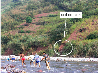
e.g. by soil erosion from the bordering valleys - or in the case of
Shennong Xi also from farm land. Algae then grow, i.e. they accomplish
at least one cell division. In case the
rate of cell division is higher
than the washing out rate, and grazing does not reduce
algal biomass
afterward, the phytoplankton organisms can succeed over several days to
a few weeks. The phytoplankton of such niches becomes introduced to the
main stream channel only by elevated water level, e.g. after flood
events such as heavy rainfalls. In case the demand for nutrients by
algae is higher than the supply/replenishment from the environment, the
algal growth becomes controlled by nutrients. This situation of low
nutrient load is typically found when rocks rather than
valleys and
soil are covering the stream bank, and no farmland is bordering the
stream. Under such nutrient-limiting
growth conditions, algae usually
need much more time to accomplish cell division and thus to increase
their biomass compared to an unlimited growth in nutrient-rich waters
much further downstream. The scenario of the growth of non-attached
algae in a stream (some forms of other algae are attached to stones in
the streambed, what are not considered here at all) is herewith just
described in a simplified form. It might give a rough idea about
phytoplankton development in a headwater that goes over into a
downstream stretch. The mutual
adjustment of algae and their
environment (other biota, physical and chemical
conditions), which
implies that algae are enabled to respond rapidly to environmental
modifications, however, is more complex and actually matches rather the
life in nature than the paraphrased description before.
Going further downstream, the deeper and wider streambed increases
considerably the retention time of the water, and the stream receives
usually more nutrients from tributaries and bordering landscape than
upstream. Reduced flow and an
enhanced nutrient availability allow
algae to accomplish cell division and thus to achieve growth while
drifting in the stream channel. Actually, in view of
phytoplankton
growth, this stretch might remember a ‘steady-state flow’ as known from
algal growth experiments in the lab. The increased biomass of floating
photosynthetic microorganisms colours the water yellow-green as indeed
seen on most photos of the navigable stretch across the Shennong
stream. The photos 1-3 and 6-7 in
the gallery, the two photos shown in
the section about the geographical location and the two photos below
indicate this green colour caused by phytoplankton. Even the water
transparency is reduced due to the floating algae; sufficient light for
photosynthesis penetrates the channel at least at a wider surface layer
of the stream. In particular, species that can adjust to low light
intensities in a turbulent water body, grow well (see adjustment of
photosynthesis described for phytoplankton in alpine lake Traunsee, S
on
the lakeriver-website). Depending on the water retention time, it is
not only
the watercolour and the phytoplankton composition but also the whole
ecosystem that changes. With increasing retention time of water, the
ecosystem of a river turns to a riverine lake and finally to a lake as
described for lake
Grosser Mueggelsee, S
on the lakeriver-website.
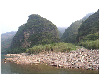
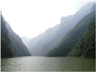
 Stream Shen Nong, 2004:
Stretch not to far upstream but with steep rocky slopes covered by
natural
vegetation of trees and bushes. The water looks green coloured.
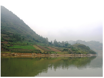 Stream Shen Nong, 2004:
This stretch of the stream is already nearby to its mouth to the
Yangtze River. Farmers grew crops on the slopes close to the water's
edge, to some extent, on terraced fields. The water looks
green-brownish coloured.
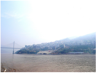 Yangtze River and city
Badong, 2004:
Yangtze River and city
Badong, 2004:
City Badong at Yangtze is close to the mouth of the Shen Nong stream.
The water looks brownish coloured.
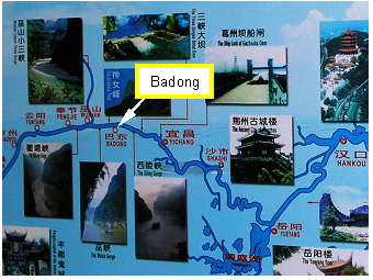 This tourist map showing the Yangtze River
basin was posted on a cruise ship in 2004.
This tourist map showing the Yangtze River
basin was posted on a cruise ship in 2004.
Close to the mouth
into the Yangtze River, the water of
Shennong Xi looks brownish green due to enhanced concentrations of
suspended solids (silt) in addition to floating green cells of primary
producers. The muddy water colour is due to soil erosion from the
bordering landscape, here often used for farming (see photo above,
taken at city Badong).
The crops are grown on the slopes on Shennong Xi even close down to the
water's edge, in some areas on terraced fields. The same was found for
the Yangtze River S, where the water
colour looks just brown without
a greenish tone.
The muddy water is nutrient rich and hence might support algal
growth.
Furthermore, water current is reduced in wider streambeds, which in
addition might promote phytoplankton development. The low transparency
of the water, however, provides insufficient light for
photosynthesis. Thus, the
huge amount of nutrient has, in principle,
the enormous potential for an algal bloom, but cannot be utilized by
algae drifting in the muddy stream or river. The dissolved
nutrients
are accumulated in the water while transferred further downstream.
Entering a broad basin as a lake or a reservoir, the suspended solids
of the river water deposit rapidly to the bottom (sediment layer) and
thus the water transparency significantly increases. This scenario of
improved underwater light climate allows phytoplankton growth. Within a
few days, the water colour changes to green as one cell
division per
day (daily growth rate = 0.693 d-1), i.e. the
doubling of phytoplankton biomass per day, can be easily
accomplished
during an initial nutrient-unlimited growth phase even in a
natural habitat (algal growth rates of nutrient-addition experiments in
the lab can be much
higher). Planktonic blooms of cyanobacteria in lakes, which
were mainly due to nutrient-rich inflows (!) are described on the
lakeriver-website for a number of shallow water basins such as the
lakes lake Taihu S, Dianchi S and
Grosser Mueggelsee S. In the Meiliang
Bay of the north of lake Taihu,
were two tributaries join into the
lake, the algal biomass measured by chlorophyll-a
concentrations is
significantly higher than at the centre of Taihu (Fig.
5 in Chen et
al.
2003 R).
More interesting within the context stated before is, that
measurements of total phosphorus and also for total nitrogen close to
the mouth where the Lujiang
River joins into Meiliang Bay, were
statistically significant higher than at any sampling station in
Meiliang Bay or the centre of the lake (see map of sampling sites in
Fig.1 in Chen et
al.
2003 R). Despite the
nutrient-rich
situation of the inflow river water, the chlorophyll-a concentration is
lower than measured at the two sites in the bay (Bay 1 and B2) in the
close neighbourhood of this mouth (see annual averages for nutrients
and
chlorophyll-a at ‘M2’ for the mouth of Lujiang River and for the sites
‘B1&2’ in the Meiliang Bay Fig.2
in Chen et
al.
2003 R).
The enormous potential for an algal bloom by
nutrient-enrichment in the
river water became just obvious when
entering the large shallow basin of the lake bay. A scum of
cyanobacteria was built up during the growth season in the Meiliang Bay
in
Taihu.
take the chance going by boat upstream
shennong xi
 Mountain stream Shen
Nong,
2004:
Mountain stream Shen
Nong,
2004:
Men were hauling boats upstream passing a
shallow section of the broaden streambed. Crops can be seen
grown on the slope.
Soil erosion of the stream bank can be further noticed on the photo.
Both, the common practice of farmers growing their crops right close to
the water's edge and the current soil erosion, indicate the recent
water level increase during the period of constructing the Three Gorges
Dam.
The photos of the Shennong stream shown on this website were mainly
taken in 2004, when the
Three Gorges Dam has been under
construction aimed at bringing up the water level to 175m
(see the
water level mark the website about Yangtze
River S).
At that early
stage in 2004, the water level of Yangtze River had been already
increased by about 70m. The damming up of Yangtze River would also have
affected its tributaries: some old/ancient habitats have been
certainly lost, other
young habitats will be established with time. The elevation of the
water level
and water fluctuation definitely alters an ecosystem like the Shennon
Xi. In case of a scenario of further anthropogenic nutrient
enrichment, however, it might have a greater impact on such an
ecosystem.
As described in the introduction for Shennon Xi, the stretch
of the 'mountain stream' can only be passed by boat as in sections of a
stony streambed, the flow becomes shallow, while on other sections the
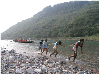
streambed is deep but very narrow. Local people were busy to organize
the tourist attraction of boat hauling or tugboat. The temperature
in an upstream section fed by springs is usually much lower than
upstream.
The visit
was in September, early autumn at Shennong Xi. People who were not
wading through the water, who were just waiting on the shore for
tourists or selling local goods were wearing long trousers. The
'boat haulers' or 'boat tuggers' preferred to wear long-sleeved shirts
due to the chilly
weather and cold water in the mountain stream.
 Mountain stream Shen
Nong, 2004:
Mountain stream Shen
Nong, 2004:
Wooden flat-bottomed boats were suitable for hauling in shallow
stony streambeds.
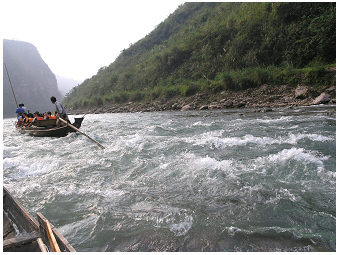
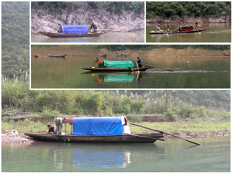 Mountain stream Shen Nong, 2004:
Even an individual fisherman simultaneously row and
steer the
boat: the short lateral oar was to row and an elongated oar with blade
to steer.
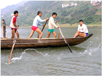
 Mountain stream Shen
Nong, 2004:
Mountain stream Shen
Nong, 2004:
Men were hauling
upstream small boats with tourists passing the shallow stretch of the
mountain streambed.
 Mountain stream Shen Nong, 2004:
The same tourism attraction activity as on the left photo, but going
downstream.
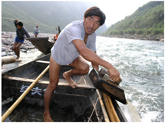 Mountain stream Shen
Nong, 2004:
Mountain stream Shen
Nong, 2004:
Emptying the flat-bottomed boat of water by dipping a wooden container.
 Mountain stream Shen Nong, 2004:
Detail of the construction of the traditional wooden boat suitable for
hauling to
pass shallow streambeds.
The wooden boats seen on
the photos above were used as fisher boats and to transport goods and
people as tourists. These
flat-bottomed boats had a broad bow and slim stern. A
varying number of oars, which were fixed on the side
planks of
the boat, was used to row the boat. An
elongated
oar with blade on the rear end was operated to steer. As
seen on the
photo below, even
an individual person could handle well both
simultaneously, to row and steer the boat S. The boats,
which were, in
particular, used for hauling to pass the shallow streambed,
had in addition a stump of mast, which was made in its simplest form
just by a stock of a tree. While hauling the boat, a rope was guided
through the slot of this short mast. On a shallower stretch, also
bamboo
sticks were used to punt the boat. Some boats had permanent shelters on
board, others just a simple cover to protect from rain and sunshine.
Another, but a similar type of wooden
fishing boats can be visited on
the lakeriver-website for the stream Huangbai at Yichang
S.
These boats have shelters, which were
permanently used on the boats. The fishing boats in Yichang were
further equipped with a
lift net S. This type of
small wooden boat (locally called 'peopod boat') is
depicted as a
sampan or
sam-pan, which describes literally the use of
only three wooden planks to make a boat. Actually, more than three
planks made the boats on Shennong Xi and Yichang. A more original type
of such a boat, however, can be visited on the website about lake Dianchi S.
The front view of a one fisherman boat with operating lift net may
rather convey the idea that
a boat can be simply made by three planks: one for
the bottom and the other two on each side S.
 >
>