geographische lage in den
österreichischen alpen
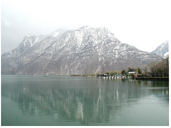
 Traunsee, 2002:
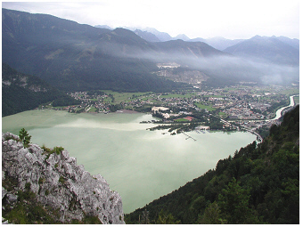
Blick vom Berg Sonnstein hinunter auf den nördlichen Teil des
Seebeckens. Die tiefste Stelle von 191 Metern liegt etwas weiter
nördlich von der Traunkirchner Halbinsel, die am Westufer,
d.h. links zu sehen ist. Die tiefste Stelle befindet sich etwa
in der
Mitte von dem West-Ost-Transekt in der Höhe des Berges Traunstein,
dessen Fuß an dem felsigen Ostufer, rechts im Bild, zu sehen ist.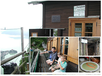 Traunsee, 2002:
Die Almhütte auf dem Berg Sonnstein („Sonnsteinhütte“)
mit Blick auf
den See ist ein beliebter Ort, um eine Rast einzulegen und
eine
Jausen essen. Es werden einfache traditionelle Gerichte hier auf 923
Metern über dem Meeresspiegel zubereitet.
Eingefügtes Detail rechts unten: Eine typische Jaus’n kann ein kaltes
oder heißes „Würstel“ mit „Gebäck“ (Scheibe Brot,
Brötchen, Semmel) bzw. einer warmen „Suppn“ (Foto), ein belegtes
Schinken-, Kas-(Käse) bzw.
Aufstrichbrot oder eine „Mehlspeis“ (Kuchen) bzw.
„Tortn“ sein. Die Hütte ist nur zu Fuß auf einem Bergweg erreichbar.
Der Traunsee (47°52’16.9''N,
13°47’34.89''E) befindet sich 422 m
über dem
Meeresspiegel
im Salzkammergut in
Österreich.
Dieser alpine See liegt nur 20 km vom Attersee
S,
35 km vom
Mondsee
S und
40 km vom Hallstättersee
S entfernt.
Der See hat eine längliche Form und erstreckt sich
vom
Süden (Dorf Ebensee) nach dem Norden (Stadt Gmunden). Mit einer
maximalen Tiefe von 191 m ist der Traunsee der tiefste See in
Österreich. Die Seefläche beträgt 25,6 km2
und das
Seewasservolumen
2302 x 106 m3.
Verglichen mit dem Mondsee, ist der Traunsee
2,7 mal
tiefer und hat ein 4,5 mal größeres Wasservolumen. Ungeachtet
dieser
Seengröße vom Traunsee beträgt
die theoretische Verweilzeit des
Wassers, d.h. die Zeit, die theoretisch benötigt wird, um hydrologisch
den gesamten Wasserkörper auszutauschen, nur ein Jahr (Tabelle 1 in
Dokulil et
al.
2006 R). Die Verweilzeit dieses tiefen großen Sees
ist damit 7 Monate kürzer als
bei dem flacheren und kleineren Mondsee.
Der Grund für die kurze
Verweilzeit des Wassers im riesigen Wasserbecken vom Traunsees ist die große
Durchflussmenge vom Fluss Traun, der rasant
durch den See fließt (siehe
Details im nächsten Textkapitel). Durch diesen Fluss ist der salzhaltige Hallstättersee
(halbes Jahr theoretische Verweilzeit) mit dem Traunsee verbunden, womit beide Seen
demselben Einzugsgebiet angehören. Der Traunsee ist hydrologisch weniger mit Attersee und
Mondsee verbunden, auch wenn diese beiden Seen in einer näheren Nachbarschaft zum Traunsee
liegen als der Hallstättersee.
So wie sich das Jahr in vier Jahreszeiten in der gemäßigten Klimazone
untergliedert und sich diese
saisonale Abfolge in den vier jahreszeitlichen Aspekten der Vegetation
beispielweise widerspiegelt, durchlaufen auch die Seen saisonale
Zyklen.
Die saisonale Sukzession in einem See ist eng an die Wassertemperatur
gebunden. Sie bedingt z.B. direkt die saisonale Abfolge der thermischen
Schichtungsverhältnisse. Aber auch andere Charakteristika, wie zum
Beispiel die Jahresdynamik der Nährstoffkonzentrationen, die
Verhältnisse der Nährstoffe untereinander, die Artenabfolge in der
Phytoplankton- bzw. Zooplanktongemeinschaft usw. weisen Muster einer
saisonalen Abfolge auf. In zumindest groben Zügen entwickeln sich die
physikalisch-chemischen und biologischen Jahreszyklen in den Seen
gleichartig, sofern die Seen in der gleichen Klimazone liegen, eine
vergleichbare Seebeckenmorphologie und Hydrologie besitzen
(d.h. es flache oder tiefe bzw. stark oder weniger stark
durchflossene Seenbecken sind) und
auch einen vergleichbaren Nährstoffgehalt besitzen (d.h.
einen nährstoffarmen oder
nährstoffreichen Wasserkörper zum Beispiel haben). Vergleichbare
Seenökosysteme, die geografisch sehr nahe liegen und vielleicht sogar
innerhalb eines Einzugsgebietes liegen und somit direkt miteinander
verbunden sind, weisen oftmals einen sehr engen zeitlichen Gleichklang
oder saisonalen Takt in ihrer Jahresentwicklung auf. Diese synchrone
Abfolge zwischen verschiedenen Ökosystemen wird in
der Seenkunde
als zeitliche Kohärenz
bezeichnet. Solche Kohärenz wird zum Beispiel paarweise
zwischen Seen verglichen, wie hier zwischen den See-Paaren der drei
großen Seen im Traun Einzugsgebiet, d.h. dem Traunsee (T), dem
Hallstätter
See
S
(H) und dem Wolfgangsee (W). Von den drei See-Paaren T-H, T-W und H-W
ist die Kohärenz zwischen dem Seepaar Traunsee-Hallstätter See (T-H) am
höchsten (Abb.2
in
Dokulil & Teubner
2002 R,
Tabelle 3
in
Dokulil & Teubner
2002 R).
Für dieses Seepaar zeigt
sich eine höhere Kohärenz sowohl bezüglich der Jahresdynamik der
Wassertemperatur, der verschiedenen Nährstoffe als auch der
Planktonentwicklung, wenn man diese mit der Kohärenz dieser
einzelnen Aspekte der anderen beiden Seenpaare, T-W und H-W, vergleicht
(siehe auch zeitliche Kohärenz und Klimaeinfluß auf Seen
bei der Beschreibung zum Mondsee
S
auf dieser Website).
 Traunsee, 2002:
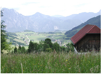
Blick vom Westufer über den See (Altmünster Bucht) und den Berg
Traunstein. Im Vordergrund vom Foto ist eine blühende Alpenwiese zu
sehen.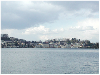 Traunsee, 2001:
Die größte Stadt am See ist Gmunden. Sie liegt am Nordende vom See, wo
zugleich der Ausfluss vom See gelegen ist.
 Traunsee, 2001:
Blick vom Ufer auf die Südbucht und die schwimmende Rohrbrücke (rechts
im Bild) vom Sodawerk in Ebensee. Die Sodaproduktion wurde hier 2005
eingestellt.Der Traunsee
ist ein beliebtes Ausflugs- und Urlaubsziel in den österreichischen
Alpen.
Wiesen und felsige
Berge umranden weite Strecken das Ufer des Sees. Die einzige größere
Stadt am Traunsee ist
Gmunden.
Diese Stadt liegt im Norden vom See, an
dem Abfluss in den Fluss Traun. Gmunden hat somit seit jeher kaum
den großen Bergsee beeinträchtigt, weder durch einen Eintrag von
Nährstoffen noch durch eine andere Verschmutzung. Neben Gmunden grenzen
nur kleine Dörfer an die urban umgestalteten Ufer neben weiten
naturbelassenen Uferbereichen an. Der nährstoffarme Gewässer-Status vom
Traunsee steht im Einklang mit einer nachhaltigen Landwirtschaft in
dieser Bergregion, dem Einzugsgebiet des Sees.
Trotz der ursprünglich-nährstoffarmen Gewässerqualität gilt der
Traunsee NICHT als Referenz-See für die Gruppe der großen,
tiefen
alpinen Seen im Salzkammergut. Andere natürliche
Besonderheiten dieses Sees, wie die ungewöhnlich kurze Verweilzeit des
Wassers in diesem großen Seebecken, die für einen alpinen See relativ
hohe Wassertrübung sowie der relativ hohe Salzgehalt, stellen diesen
See als
individuelles Ökosystem gegenüber anderen alpinen Seen heraus. Darüber
hinaus sprechen auch die potenziellen Auswirkungen der Einleitung von
mineralisch-salzhaltigen
Abwässern im Zuge der Sodaproduktion gegen eine
Einstufung als natürliches Referenzgewässer (die Geschichte der
Salzgewinnung und deren Bedeutung für das Seenökosystem wird im näheren
Detail für den
benachbarten Hallstätter
See
S
auf dieser Webseite beschrieben).
All diese besonderen Aspekte sind nicht unerheblich, sodass
wir bei dem Traunsee nicht von einem typischen Alpensee
sprechen könnten. Die limnologischen Besonderheiten dieses
Sees werden im Detail in den nachfolgenden zwei Abschnitten beschrieben.
the river traun: a turbid plume flows
through longitudinal the lake
River Traun is the main
tributary
of Traunsee and enters the lake on the south
shore, the shallow bay areas close to the village Ebensee. The river
passes the
lake along
the longitudinal extension from south to north and flows out at the
town Gmunden. The water of the river mainly distributes small particles
of inorganic material from the alpine catchment and riverbed into the
lake which colours the lake
azure blue slightly milky green. The turbidity
of the water in Traunsee is hence highest in the south, at the inflow
of River Traun
(3D-lake-plots of turbidity in Fig.6
in
Dokulil & Teubner, 2002 R).
The lake becomes less turbid, the closer the water to the north end of
the lake flows. Other lake parameters as e.g. the pH
value, the chloride
concentration and the conductivity
values follow in principle this variation pattern of the longitudinal
extension from the southern river inlet to the northern river outlet (Figs.4&7
in
Dokulil & Teubner, 2002 R;
see also the last
paragraph of this page
about the lake site impacted by industrial tailings by salt
mining
studied from December 1997 to October 1998). The nutrient
ratio
of nitrogen to phosphorus (N:P) at the water
surface layer,
however,
revealed a different pattern than simply following the south-north
transect. The ratio of N:P at water surface from 0 to 20 m
seems to
represent rather the
depth heterogeneity
of the large water basin
comprising shallow
bays and deep areas with steep slopes near the deepest site of
191 m (see N:P in Fig.7
in
Dokulil & Teubner, 2002 R).
 Traunsee und der Fluss
Traun, 2002:
Traunsee und der Fluss
Traun, 2002:
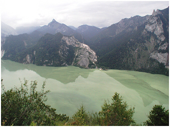
Blick vom Berg Sonnstein auf die südliche Bucht und das Dorf Ebensee.
Der wichtigste Zufluss ist die Traun und ist im Tal auf der rechten
Seite im Foto zu sehen.
 Traunsee, 2002:
Blick vom Sonnstein Berg auf den See. Das Foto ist im Sommer
aufgenommen. Zu dieser Jahreszeit entlädt der Gebirgsfluss Traun große
Mengen mineralischer Schwebestoffe (mineralische Partikel) in den See.
Diese Fluss-„Wolke“ färbt den See azurblau bis milchig grün. In diesem
extrem nährstoffarmen See ist daher die hellgrüne Wasserfarbe NICHT
durch Massenentwicklungen von Algen bedingt.
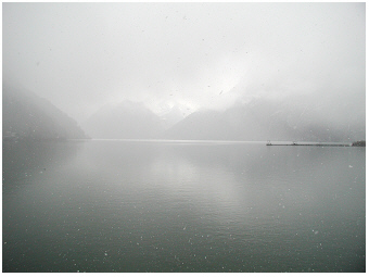
More than one-third of annual precipitation usually occurs in
summer in the Traunsee district. July is the rainiest month
contributing about 12 % to annual precipitation. After periods
of high
precipitation, the river plume of inorganic suspended solid material
can be readily identified on the surface of the lake by measuring the
turbidity along the vertical profile (see cloudy water in the both
photos above). The
water of Traun River,
exemplified for the year 1999, was in August about 13 °C and
hence
stratified in the lake at a surface depth layer with corresponding
water temperature (see
depth profile T5 and T9 in Fig.5
in
Dokulil & Teubner, 2002 R).
The river
plume horizon in the lake was then seen by a sharply
stratifying turbid horizon in the top
6.5 to 20 m along the 140 m depth
profile nearby the south bay. Even further away from the Traun-inflow,
at the deepest site (called site Viechtau, 191 m depth), the
stratifying
plume showed up as an enhanced inorganic turbidity in the surface
layer. The River Traun hence affects Lake Traunsee twofold. The turbid
river plume lowers water transparency in the nutrient-poor, i.e.
oligotrophic,
freshwater system. Further, the elevated river discharges
contribute mainly to a rapid renewal of water in the huge freshwater
basin.
the plankton in lake traunsee:
a deep lake without a chlorophyll maximum in the deep layer
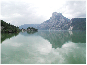
 Traunsee, 2001:
Blick vom Ufer weit über den großflächigen nördlichen Teil des Sees. In
der Ferne ist die Halbinsel Traunkirchen am Westufer (Foto rechts) und
der Berg Traunstein am Ostufer (Foto links) zu sehen.
The lake is characterized by low nutrient availability for
growth of algae and photosynthetic bacteria drifting at the surface of
the water basin. In particular, the phosphorus
concentration is low. Total phosphorus, measured for
depth-integrated samples from 0-20 m, has an annual average of 7.5 µg
per L (0.24 µmol L-1) for the
deepest site and
8.7 µg per L (0.28 µmol L-1)
for the south
‘Ebensee’ bay (December 1997 to October 1998, Fig.2
in
Teubner 2003 R).
This nutrient-poor,
i.e.
oligotrophic state corresponds to a low biomass development of algae
and cyanobacteria in Traunsee. A rough estimator of this biomass is the
photosynthetic pigment chlorophyll-a as described in greater detail for
lake Mondsee
S.
The annual average of chlorophyll-a
concentration measured for depth-integrated samples
(0-20m) was at the deepest site of Traunsee 1.36 µg per L only. The
main chlorophyll development was found mid May-June with concentrations
of
2.37 µg per L associated with annual peaks
of photosynthetic rates (Fig.8
in
Dokulil & Teubner 2003 R, Fig.1
in
Teubner & Dokulil 2002 R).
In view of the poor nutrient availability, Traunsee
is
close to ultra-oligotrophic Attersee
S
(Fig.8
in
Teubner 2003 R).
The photosynthetic
microorganisms
drifting in the water, i.e. the phytoplankton
organisms in Traunsee belong to diverse algal groups
(diatoms, cryptophytes, dinoflagellates, chrysophytes, chlorophytes)
and cyanobacteria as is common in other lakes. As exemplified by the
year 1998, the diatoms
contributed with up to 93 % most to the phytoplankton in spring
in Traunsee (page 1587
in
Teubner 2003 R).
Seasonality of phytoplankton in 1998 can be mainly
described by diatom biomass changes. As diatoms specifically utilize
the nutrient element silicon, the top water layer of predominant
photosynthetic activity (0-20 m) coincided with relative high
silicon
exhaustion in comparison to the other two main nutrients as phosphorus
and nitrogen. The main diatom species in Traunsee were Aulacoseira
ambigua, Asterionella formosa, Tabellaria flocculosa, Fragilaria
crotonensis, F. ulna and various
unicellular centric diatoms. Cryptophytes contributed up to 55% of
total phytoplankton in late summer and autumn. Other algal groups as
dinoflagellates, chrysophytes, chlorophytes and cyanobacteria were of
minor importance and reached not more than 26% of the total biovolume
during the annual cycle.
In terms of the size
structure of
phytoplankton, the small organisms are much more abundant
in the plankton community of alpine lakes than those of large
biovolume. It could be shown, that in Lake Traunsee the small algae,
which refer here to the algal size fraction that has passed a filter
with the mesh-size of 10 µm, contributed far more than the half to
total chlorophyll (63% were measured for Traunsee, the same was valid
for Mondsee, page 316
in
Teubner et al. 2001 R).
Measuring photosynthesis
in Lake Traunsee, the small size fraction of phytoplankton (0-10µm)
indicated a relative high light utilization efficiency and relative
high portions of light-harvesting to photo-protective pigments than the
size fraction of larger cells (larger than 10µm, Figs.4&8,
Table 2
in
Teubner et al. 2001 R).
This allometric rule, that
cell size
determines photosynthetic properties, was not only
measured for phytoplankton in Traunsee, but also other for other alpine
lakes as Mondsee and Lucerne (Teubner
et al. 2001 R).
 Traunsee, 2001:
Seichtes Ufer in der südlichen Bucht – die erhöhte Wassertrübe lässt
sich hier im Wesentlichen auf höhere Konzentrationen von anorganischen
Schwebfeststoffen zurückführen.
Das Ufer liegt in unmittelbarer Nähe
von der Mündung des Flusses Traun. Der Trübehorizont dieses
Flusswassers lässt sich weit oberhalb des Seegrundes, nämlich in
den mittleren Tiefehorizonten des Sees nachweisen (siehe Details im
Text zu
„Der Fluss Traun: eine trübe Wolke durchströmt den See in Längsrichtung
/ The
River Traun: a turbid plume flows through longitudinal the lake“).
Weiters
liegt in der südlichen Bucht eine
diskontinuierlich betriebene Einleitungsstelle von
industriell-mineralischen Abwässern aus anfallenden Felsrückständen bei
der Sodaproduktion in Ebensee, was zur damaligen Zeit phasenweise dann
auch zu einer erhöhten Wassertrübe in der Bucht
beitrug. Die Sodaproduktion wurde im Jahr 2005 eingestellt.
Carbon is a major element of biomass. The
carbon ratio of phytoplankton to bacterioplankton indicates the portion
between photosynthetic and non-photosynthetic microorganisms drifting
in the water column. The carbon ratio on the surface was 1.25 and
decreased moderately to 1 at 20 m for Traunsee in 1998 (Fig.4C
in
Teubner 2003 R).
These values
indicate the dominance of
photosynthetic microorganisms versus bacterioplankton at 0-20m.
This top layer coincides indeed with the main depth distribution of
algae and photosynthetic bacteria. In the year 1998, the chlorophyll-a
concentration of phytoplankton had an annual average of 1.6, 1.4 and
1.1 µg per L at 0.5, 10 and 20 m,
respectively. This distribution
pattern corresponded to the vertical light availability for
phytoplankton photosynthesis. The euphotic
zone, which refers to the top water layer where at least
1 % of light is penetrating, varied between 9-17 m
and has an annual
average of 12.2 m at the
deepest site (Table 1
in
Teubner & Dokulil 2002 R,
Fig.2
in
Teubner 2003 R).
The euphotic zone exceeded the mixing zone
by 2-3 m in Traunsee most of the time in summer as is commonly
found in
other alpine lakes (see e.g. Mondsee
S).
The zone of 0.01% light
intensity varied
from 14 to 26 m during growing season in Traunsee
and was
on average 19 m. The dim-light zone below the euphotic zone
was hence
at
12 to 19 m in Traunsee. In other alpine lakes, a chlorophyll
peak in
the
deep dim-light layer is found and refers to a phytoplankton peak
development in the metalimnion. Such a ‘deep chlorophyll maximum’,
which commonly occurs in moderately nutrient-enriched deep alpine
lakes, was not found in oligotrophic Traunsee. The deep phytoplankton
biomass peak in Mondsee and Ammersee was mainly built by the
cyanobacterium Planktothrix
rubescens, usually associated with low abundances of other
deep living algae such as diatoms and cryptophytes. Planktothrix
rubescens occurred even in Traunsee but was
rare. In the year 1998, this cyanobacterium was seldom found, in
September and December and contributed only 0.1-0.3 % to total
biovolume. From 20 to 40 m depth, the carbon ratio of
phytoplankton to
bacterioplankton decreased drastically in Traunsee, namely from 1 to
0.5, indicating the predominance of bacterioplankton. A few
phytoplankton cells may stratify ‘by chance’ even at 40 m
depth as low
chlorophyll-a concentrations of less than
0.4 µg per L at this dark
layer of deep metalimnion close to the hypolimnion were measured. The
metalimnetic layer avoids entrainment of particles as described in more
detail for Lake Mondsee.
 Traunsee, 2001:
Der Süden vom großen Traunsee - die „Ebenseer“ Bucht ist im
Verhältnis zur tiefsten Stelle relativ flach. Die Tiefe beträgt hier
nämlich nur etwa 50 m.
The signature that pelagic microorganisms are mainly
inhabiting the top 20 m layer, can also be seen by vertical
profiles of proportion among
the three fractions
of the total phosphorus pool, the annual DRP:DOP:POP
triple ratio (Fig.5A&C
in
Teubner 2003 R). The top
20 m at the deepest site refer to high
portion of
particulate-biotic phosphorus (POP) than compared to the other two
fractions, the dissolved reactive-inorganic (DRP) and the mainly
dissolved organic phosphorus (DOP), respectively (Fig.5A
in
Teubner 2003 R). From 20m to
40 m, the
portion of biotic phosphorus relative two the other two fractions
decrease drastically (see distance of data points refering to the
0-20 m surface layer and the point of 40 m depth Fig.5A
in
Teubner 2003 R).
The biotic fraction is the only fraction of
phosphorus that decreases over magnitudes with depth, while the
proportion between the two dissolved fractions, is more or less uniform
over depth with slight increases toward DRP near the bottom. Further
the
annual mean of the TN:TP:SRSi ratio (Fig.5B&C
in
Teubner 2003 R),
which refers to the stoichiometric
proportions between the
main nutrient elements utilized by photosynthetic
organisms, i.e. nitrogen, phosphorus and silicon, designate the top
20 m
layer as the main phytoplankton layer indicated by a strong
silicon exhaustion relative to
N and P. As described for another lake, phosphorus is a
nutrient element of very short turnover time of about hours to days. As
a rule of the thumb, the turnover for nitrogen takes longer than for
phosphorus, from days to weeks. Both nutrient elements can be recycled
within a season and are hence promptly or fast replenished for algal
utilization. The turnover time needed of silicon is even longer,
usually weeks to months. For that reason, the replenishment of silicon
after exhaustion from near bottom layer is often linked to seasonal
events as mixing in deep (!) lakes. To take account of the rapidly or
in moderate time recycled phosphor and nitrogen, respectively, usually
the total phosphorus pool and also in many cases the total nitrogen
pool is chosen as the resource nutrient pool. In the case of silicon,
the dissolved fraction of soluble reactive silicon is the only
ecologically relevant nutrient source (and not total silicon), as
continuous supply is hampered by long turnover time. The mismatch in replenishment of the three
nutrient elements is also seen by the portions of
dissolved inorganic fractions of each element, DIN:DRP:SRSi (DIN is
dissolved inorganic nitrogen) in Traunsee (Fig.5B&C
in
Teubner 2003 R).
This triple ratio
follows,
in principle, the depth profile of TN:TP:SRSi except for phosphorus as
here the resource nutrient pool (SRP in the lake water) is consistently
underestimated.
Vertical depth distribution was not only found for algae and
bacteria but also for planktonic micro-animals in Lake Traunsee. A
particular high species
richness along depth profiles with seasons was found for ciliate assemblages
.
More than 50 ciliate taxa could be identified in Traunsee. The most
frequent ciliates were Rimostrombidium
brachykinetum/Rimostrombidium hyalinum and Balanion
planctonicum (list of species in Table 2, scheme of
graphical illustration in Fig.5A
in
Sonntag et al. 2006 R). The
seasonal pattern of depth distribution of these aquatic
protozoa as
ciliates and non-photosynthetic small flagellates (heterotrophic
nano-flagellates), was mainly determined by the depth distribution of
their potential food sources, e.g. algae and bacteria (Fig.4
in
Sonntag et al. 2006 R). A strong
increase or decrease of the abundance of ciliates,
i.e. of positive or negative net-change of ciliate abundance by growth
or loss at a certain time-interval, was necessarily associated with
pronounced shifts in species composition. Further, the persistence of
ciliate composition, was only found at
time-intervals of (almost) zero abundance net-changes. These particular
periods
refer to an ecological steady state during seasonal development of
ciliate assemblages. Such net-change
response curves followed a bell-shaped distribution pattern
and were not only valid for ciliate assemblages (Fig.2
in
Sonntag et al. 2006 R), but also other
plankton organisms (see phytoplankton in lake Ammersee
S,
Fig.7
in
Teubner et al.
2003 R).
A multidisciplinary study was carried out to answer questions
to what extent the ecology
integrity of Lake Traunsee was affected by industrial
tailings by salt processing from soda works at the south bay, the
‘Ebenseer Bucht’. The biovolume and chlorophyll-a
concentration of the planktonic photosynthetic microorganisms
was at the site with the slight phosphorus enrichment, site Ebensee
Bay,
on average nearly the same when compared with the deepest site (see phytoplankton
biovolume in Fig.2A&E
in
Teubner, 2003 R; see
chl-a
in Fig.8
in
Dokulil & Teubner, 2002 R). According to the
phosphorus availability at Ebensee
Bucht, we could expect, however, an even higher biomass of plankton
organisms. As seen from Fig.5A&D
in
Teubner (2003 R), about 11 %
less phosphorus was bound by planktonic organisms to build up biomass
at the impacted site Ebensee Bay when compared with the
deepest site
(based on annual average during the investigation period from December
1997 to October 1998). This relative (!) low value of microbial biomass
in the surface layer at Ebensee Bay could be seen as an inhibition of
primary producers due to lowered
water transparency.
According to in situ
measurements of primary production, the phytoplankton at Ebensee Bay
represented indeed a phytoplankton
community, which was acclimated
to
low-light conditions (see significant higher values of the
maximum
light utilization coefficient for phytoplankton at Ebensee Bay than at
the deepest site; Tables 1&2
in
Teubner & Dokulil, 2002 R). Measurements of
the underwater
light-climate from April to October 1998 have shown that the
euphotic zone
(Zeu) was on average
2 m shallower at Ebensee
Bay
(Zeu = 10.2 m) than at the deepest site
(Zeu = 12.2 m, Table1
&
Fig.1F
in
Teubner & Dokulil, 2002 R).
This reduced water transparency in the bay was
caused by turbidity due to industrial tailings and/or suspended solids
inflowing by the River Traun during the investigation period from
December 1997 to October 1998. Besides planktic
community also benthic organisms,
i.e. the organisms that live attached to shore line material as e.g. on
the surface of stones, were in detail studied. It could be shown, for
example, that the benthic
diatom community adjusted to higher salinity
nearby the inlet of industrial tailings when compared with other sites
studied along the lakeshore of Traunsee (Wunsam et al.
2002 R).
The species
composition shifted here toward higher abundances of diatoms (e.g.
Achnanthes minutissima),
which are known to tolerate saline habitats.
The indication of the saline environment by benthic diatoms was not
well found in all seasons but was most pronounced and statistically
significant during late autumn. The long-term
development of
concentrations of chloride and oxygen at lake surface and bottom layer
are displayed for Lake Traunsee in graphs by Jagsch et al.
(2002 R),
and are
discussed in a more detail on the lake Hallstaetter
See
S
website when
comparing the both saline lakes. The main outcome of other studies
about the ecological integrity of Lake Traunsee in 1997 and 1998 is
summarized in a special journal volume in aquatic sciences
(Water Air
Soil Pollution-Focus 2, 2002
).
 >
>